 Irish Independent – WALK OF THE WEEK – Christopher Somerville
24 April 2010
56. Attychraan Loop, Limerick/Tipperary Border
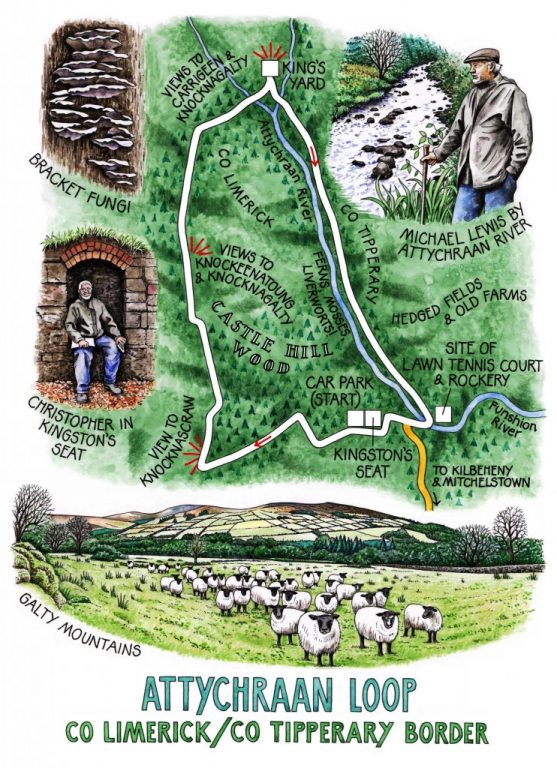
A steamy morning on the Limerick/Tipperary border, the Galty Mountains hiding their snow-streaked heads in mist, and a pale sun playing peek-a-boo beyond the clouds. Jane and I had been meaning to tackle the Galtees from this southern side for some time; so when Michael Lewis, local historian and dedicated member of the Ballyhoura Bears walking club, offered to show us some of the secret glories of Galty Castle wood, we know the moment had come. As we climbed the squelchy path up the edge of the wood under beech buds still closed fast against winter, Michael began to talk of local landlord Big George Kingston and his inexhaustible appetite for the high life.
‘Big George’s father died when he was young, and his mother held him off from his fortune for the next 30 years – she was strange herself, more interested in her little lapdogs than her children by all accounts. Anyway, once Big George had inherited, there was no stopping him! He used Galty Castle as his hunting lodge, ran riot, and basically beggared the whole family.’
The castle and over 100,000 acres had to be sold. The Buckley family who bought it all in the 1860s lived the cucumber sandwiches and tennis party life for a couple of generations until the land settlements saw the end of them. A local man bought the castle in the 1940s, couldn’t afford to maintain it, and knocked it – the stone going to build the church at Glanworth a few miles south-west.
Michael’s arm swept out across the handsome profiles of Knockeenatoung and Knocknagalty, out on our right as we went up through the emerald green light of the moss-choked wood. His finger traced out the patterns of hedged fields on the far side of the valley. ‘Those hedges would have been put in by the Kingstons from the mid-18th century onwards – Big George’s father Robert was a big agricultural improver. Once the newly-arrived landlords got settled and felt a bit more comfortable in their own skins, so to say, they were all for improving their estates, generally speaking.’
Michael gestured to the ragged peak of Knocknascraw. ‘There’d be booleying houses, kinds of summer farms, up there. They’d come down to Mitchelstown every now and then to market the butter they made and to go to Mass. They’d have a house of rough old bog timber with a roof of scraws and a patch of potatoes. But then the landlord slapped on a tax of £3 a cow. The booley people couldn’t afford that. So then …’ Michael’s hand eloquently indicated the abandoned farmsteads scattered across the slope of Knocknagalty.
The hand-to-mouth herdsmen of those hard times would nod in approval if they could see the ingenious diversification that today’s Galty farmers operate in order to make a living. At King’s Yard, a mountain farm in a cleft of the Attychraan River that looks up to Carrigeen and Knocknagalty, Bridget and Stephen Ryan have developed a walkers’ car park, a camping ground, a snack place, showers and all the other facilities that walkers and climbers in the Galtees need. It’s a brilliant use of space and location. We had a cup of tea and a yarn with Bridget, then went down along the noisily chattering river in its pebbly bed of many colours – a damp, dank hollow in the hills, rich in feathery ferns and liverworts like glistening, multiform green tongues.
As we turned up the homeward path, Michael Lewis pointed out a patch of scrub held in by a mossy retaining wall. ‘That was the lawn where the Buckleys played tennis, with a wonderful rockery framing it – all smothered and gone now.’ I perched myself in the little scoop-backed grotto called Kingston’s Seat and gazed out over the lawn to the site of the vanished castle, thinking of the Buckleys serving and rallying, munching crustless sandwiches and sipping tea between sets in the fragrance of the rockery, secure in a world that couldn’t have been more remote from their tenants just up the mountain and over the hill.
WAY TO GO
MAP: OS of Ireland 1:50,000 Discovery 74; downloadable map/instructions (highly recommended) at www.discoverireland.ie/walking.
TRAVEL:
Rail (www.irishrail.ie): Caher (7 miles)
Bus (www.buseireann.ie): Service 8 to Kilbeheny (3 miles)
Road: M8 Jct 12; immediately right off N73 Mitchelstown road through Kilbeheny. Just beyond, left (brown ‘King’s Yard’ sign); right (‘National Looped Walk Trailhead’); left into Galty Castle Wood, to car park.
WALK DIRECTIONS: Up steps; follow trail (purple arrows/PA and blue arrows) beside wood. In ½ mile, right (PA) uphill through trees of Castle Hill to meet forest road. Right to King’s Yard farm. Descend to cross Attychraan River; then fork right (PA) along river. Right again (PA) under Castle bridge; recross river (PA), follow track to road. Ahead to bend; up steps and path (PA) to car park.
LENGTH: 3 miles: allow 1½ hours
GRADE: Easy
DON’T MISS … !
• view of Galty Mountains from top of Castle Wood
• horned sheep at King’s Yard
• mossy mill race and bridge below Galty Castle site
REFRESHMENTS: King’s Yard Farm; or picnic
ACCOMMODATION: Deebert House Hotel, Kilmallock (063-31200; www.deeberthousehotel.com); or camp at King’s Yard, Knocknagalty, Kilbeheny (025-84903; www.kingsyard.wordpress.com)
WALKING in IRELAND: Walking tour operators, local walks including Discover Ireland’s National Loop Walks, walking festivals throughout Ireland: www.discoverireland.ie/walking.
• Ballyhoura International Walking Festival, Co Limerick, 1 – 3 May: http://www.ballyhouracountry.com/events
• Midlands Walking Festival, Westmeath: 7-9 May 2010 (brian@walkingireland.ie)
• Dunmore East Walking Weekend, Waterford: 21-23 May 2010 (www.dunmorewalks.com)
• Knockmealdown Crossing Mountain Challenge, Waterford/Tipperary: 24 April (www.peaksmcclonmel.ie)
INFORMATION:
Ballyhoura Fáilte Tourist Information Office: Kilfinane, Co Limerick (063-91300); www.ballyhouracountry.com
csomerville@independent.ie