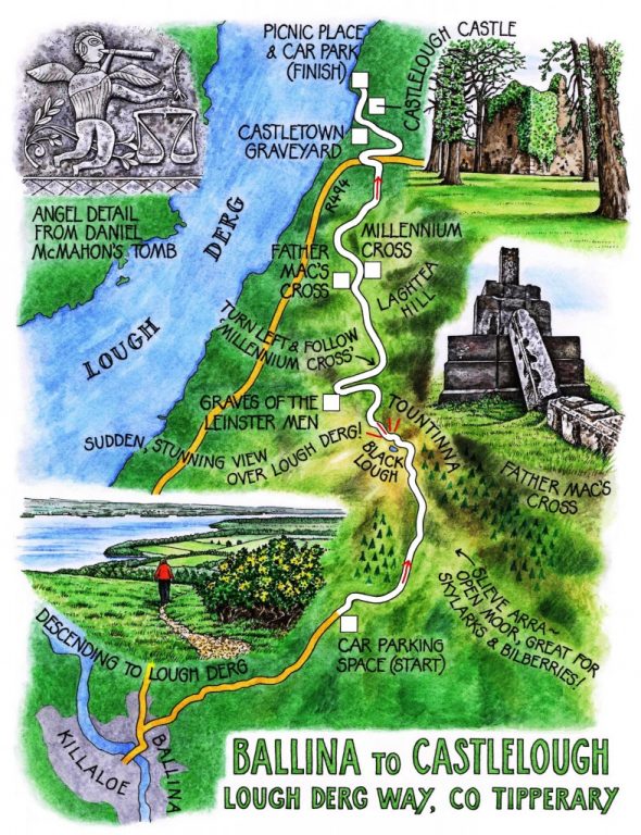
Irish Independent Walk of the Week Christopher Somerville
2 July 2011

No 102: Ballina to Castlelough, Lough Derg Way, Co. Tipperary
‘We’ve finally got most of the Lough Derg Way off-road!’ announced the press release. ‘Re-launching! Come and try out the new route!’ Jane and I couldn’t make the re-launch itself, but as soon as we had a spare day we were across to Lough Derg with the boots on (and the gloves, scarf and hat – it was a brisk enough day in West Tipperary).
Killaloe and Ballina, twin towns at either edge of the many-arched bridge that pinches in the lower waist of Lough Derg, have each a case of swollen flanks, the result of a paw-stroke or two from the Celtic tiger. Driving up the steep little lane above Ballina we looked back down green slopes up which serrated grey and white ranks of houses had crept. The eye skipped over these contemporary nodes in the landscape to settle on the pleasing huddle of multi-coloured old Killaloe, across the bridge in County Clare, with the forested arms of Slieve Bernagh rising beyond to a high bald nape of mountain. As for the great salamander-shaped waterway of Lough Derg, 30 miles from toe to tip, the pride and icon of the region – that was nowhere to be seen. The slope of the land had it hidden entirely away.
Near the crest of the road we parked and set out along a stony track across the brown shoulders of Slieve Arra. For all its modesty of height and extent, this low range of shaly, slaty hills overlooking the south-east shores of Lough Derg is wild enough, a stretch of heather and moor grass studded with bilberries, shelter for red grouse and skylarks. The nearest eminence to the lough, Tountinna, sprouts a fine crop of telecommunications masts. We stopped for a sandwich above the bright wind-rippled disc of the Black Lough, then went on to the summit and a sensational view over Lough Derg, all the more stunning for the suddenness with which it bursts on a walker coming up from the south. A sprawl of sky-blue water in a green frame of hills, scattered with white villages along the shore, making a great right-handed sweep before turning north beyond a crocodile snout of a peninsula, out and away into the haze. ‘This must be one of the best views in Ireland,’ said Jane in awe.
In a grassy clearing in the scrub below, half a dozen boulder slabs lay in a loose group. The Graves of the Leinster Men, said the notice board. Seemingly Gormlaith, wife of Brian Boru, was not too happy when she discovered that, unbeknown to her, the King of Leinster was making his way to the High King’s residence at Kincora to claim the hand of her daughter. She planned an ambush behind Brian’s back, and had the unfortunate suitor and his retinue slaughtered at this spot.
Now Laghtea rose ahead, a brown speckled neck of hill. We turned along the ridge, aiming for twin targets at the summit – the squat stump of Father Mac’s Cross, and the slender silver Millennium Cross beyond.
Father Mac’s Cross, erected in 1932 in honour of that year’s International Eucharistic Congress in Dublin, only lasted a year before it toppled – too much weight of concrete and not enough steel in the core. It lies in picturesque ruin like some allegorical installation. The tall Millennium Cross harped quietly to itself, the wind thrumming in the bracing wires.
We came steeply off the ridge down an old walled lane into low pasture country. The Lough Derg Way pointed us forward, across fields towards the lake shore and the massive ruin of Castlelough Castle. Here we lingered in Castletown graveyard, admiring the tombstone of Daniel McMahon – an angel blowing the Trump of Doom, and Daniel arising from his coffin in the form of a heaven-bound skeleton with a bird’s head, its slender fingerbones already elongated in anticipation of the angel wings they’d soon be unfurling.
WAY TO GO
MAP: OS of Ireland 1:50,000 Discovery Sheet 59; downloadable map/instructions at http://www.shannonregiontrails.ie/media/Media,10376,en.pdf
TRAVEL: M7 to Jct 27; R494 to Ballina. Pass top of road leading to bridge and Killaloe; in 200m, right (brown ‘Lough Derg Way/LDW’ fingerpost). Up mountain road for 3 km. Parking space on right, just before forestry and 200m before LDW bears right off road.
WALK: From parking space, up road for 200m, right up stony track, follow Lough Derg Way yellow arrows (LDW) across heath to road. Right (LDW) past masts to reach summit mast. On down track (LDW) to road by mast and Leinster Men’s Graves. Right for 400m, then left, following ‘Millennium Cross’ fingerpost (NB: LDW fingerpost here may be pointing wrong way!) to reach Millennium Cross. Left here, steeply downhill (LDWs) to lane. Right (LDW) for ½ mile (0.8 km); left (LDW) over stile. Follow stiles and LDWs over fields, down to cross R494. Left for 100m to lookout; right (LDW) through wooded section. In 300 m, left through shank of wood to road. Left (LDW) to pass Castletown graveyard and Castlelough Castle to Castlelough car park/picnic place.
Pick up 2nd car here, or ring taxi (Silver Cabs, 087-611-1103; or Hackney Cabs (087-314-7071)
LENGTH: 7 miles – allow 3-3½ hours
CONDITIONS: Hill paths
GRADE: Moderate (NB: Very steep descent from Millennium Cross)
REFRESHMENTS: Picnic on Laghtea Hill
WALKING in IRELAND: Walking tour operators, local walks including Discover Ireland’s National Loop Walks, walking festivals throughout Ireland: www.discoverireland.ie/walking.
BOOK: Christopher’s book Walking in Ireland (Ebury Press) contains 50 of his favourite Irish Independent walks.
INFORMATION:
Killaloe Tourist Office: Killaloe Heritage Centre (061-376866)
csomerville@independent.ie