Irish Independent Walk of the Week Christopher Somerville
14 May 2011
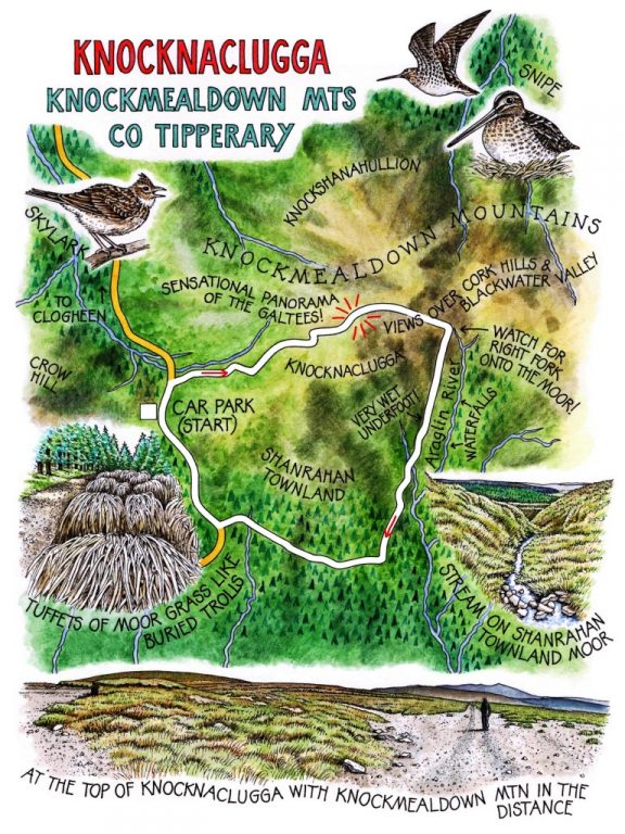
No 96: Knocknaclugga, Knockmealdown Mountains, Co. Tipperary

A cold and cloudless morning on the Tipperary/Waterford border, and an early wind with a bite in its teeth over the Knockmealdown Mountains. As we drove the back lanes to Shanrahan crossroads they stood up high and handsome, filling the sky to the south with their long humpy spine, a upthrust of hills in every shade of misty blue. Once up on Crow Hill at the summit of the mountain road the colours hardened and changed to sombre heather browns and stony greys, and the Knockmealdowns rolled out on all sides in a sea of gently rounded billows.
We set out into the wind, following the Blackwater Way’s mountain section up towards the low rise of Knocknaclugga. Now the sun came peeking through the vapour overhead, lighting up the hills so that browns became fox-reds and the heather and grass sparkled with dew diamonds. There were broad patches of pale green reindeer lichen, branched like crisp little antlers, and tuffets of pin moss so soft to the sight that it made me want to lie down and press them to my cheeks. I’d have got hell’s wet if I had, however.
As we made the gentle ascent, a wonderful view came springing into sight. In the north, across a wide vale of half a dozen rivers, the Galtees stood in all the glory of their southern aspect, the peaks of Lyracappul and Knockateriff running east to the central summit of Galtymore, with a dent in his noble backside and Galtybeg’s camel hump under his right armpit. Then to the south, the washed blue cut-outs of hill ranges, line behind line, rising from the farmlands around the River Blackwater.
This is a view to make anyone stop and stare. While we were doing that, up came Michael from Kilkenny. ‘A fine day, thank God! Are you doing the Knocknaclugga Loop? Oh, I just love the Looped Walks – I’ve done dozens of them.’ He swung his hand round the horizon. ‘Anywhere within an hour and a half of where I live. The great thing is, you can park your car and know you’ll come back to it at the end of the walk. They’re well marked, too, which is great for a fellow like me that doesn’t get on too well with the old map and compass.’
Michael strode on, shoulders back, wind in his face, the picture of a man of contentment, and we followed his rapidly diminishing figure over the all-but-imperceptible brow of Knocknaclugga. Red grouse went whirring off like explosive little mortar shells, giving out their high pitched maniac’s giggle of an alarm call. A snipe got up from boggy ground and zigzagged away, twisting and turning so that the sun caught his wings and flashed from them like tiny polished sabre blades. Skylarks ascended, reeling out unending song. It was a beautiful walk across the Knockmealdowns – a little slice of heaven, put it like that.
We descended a slippery slope into a wide valley of peat moorland, with the sharp peaks of the eastern Knockmealdowns dead ahead in muted blue. Down by a loudly chuckling mountain burn we turned off the Blackwater Way into a roadway of mauve-coloured stones, then out onto the moor of Shanrahan townland on a sloppy track where peat squelched and water spurted under our boots. The heather was indented by hundreds of dark peat pools, the margins of their iridescent water winking with sunlight fractured by thousands of frantically wriggling, newly hatched tadpoles. Caddis grubs clung to stream boulders, their DIY shells of stone fragments causing the minutest of ripples in the water. The moor, seeming so bare and lifeless to the casual glance, revealed itself as bursting with life, a seedbed for countless million unregarded organisms.
We forded rushing burns and got onto a better track leading down off the moor into forestry. A last glimpse of waterfalls silently crashing far back up the infant Araglin River, and we were into the cold shade of conifers. On by banks of coarse, silvery tussocks of grass, like a tribe of long-haired trolls buried up to their ears in the forest; out of the trees, and up to the summit of the mountain road and the splendour of the sunlit Galtees to set the seal on the morning.
WAY TO GO
Map: OS of Ireland Discovery 74; downloadable map/directions at discoverireland.ie/walking
TRAVEL: R665 Clonmel-Mitchelstown; at Shanrahan crossroads (1 km west of Clogheen), left (‘Shanrahan Cemetery’) up mountain road for 3 km. Car park by trailhead map at summit of roads.
WALK: Left along road for 150 m; right, following Blackwater Way (yellow man, yellow arrows) and Knocknaclugga Loop (purple arrows (PA) for 2.5 km over Knocknaclugga and down to metal stile. Right here off Blackwater Way (PA) on stony roadway. In 200m, right off roadway on boggy moor track (PAs). In 1 km meet sunken lane; follow it off moor (PAs), through forestry to road. Right to car park.
LENGTH: 5 miles – allow 2 ½ hours
GRADE: Moderate
CONDITIONS: Rough mountain paths, boggy moor tracks, forest roads. Wet and muddy in parts. Hill walking gear and boots.
REFRESHMENTS: Picnic
DON’T MISS
• Views south over Cork mountains
• Views north over Galtees
• Birds of the mountain: pipit, lark, snipe, hen harrier
WALKING in IRELAND: Walking tour operators, local walks including Discover Ireland’s National Loop Walks, walking festivals throughout Ireland: www.discoverireland.ie/walking.
INFORMATION:
Clonmel Tourist Office: The Main Guard, Clonmel Town (052-612-2960)
csomerville@independent.ie