Irish Independent Walk of the Week Christopher Somerville
7 May 2011
No 95: Larganmore Loop, Ox Mountains, Co. Mayo

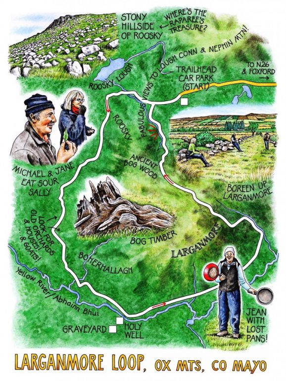
Someone once told me that to walk without a good knowledge of Irish in the west of Ireland, with its plethora of expressive place-names, is to walk blind and deaf. All five senses were guaranteed to be on full alert today, thanks to the two walkers who’d agreed to accompany Jane and me around the flanks of Larganmore, in the Ox Mountains of north-east Mayo. Michael Grehan, a local farmer and participant in the Rural Social Scheme, has taught himself the name and derivation of every stick and stone of his native mountains. Jean Beattie, supervisor of the RSS scheme in the Foxford area, is a born enthusiast for landscape, life, the natural world and the tallest of tales.
‘Captain Gallagher, now, he was a raparee around here, famous for shoeing his horse back-to-front to mislead the law. When they finally caught him and tried to force him to reveal where he’d buried his treasure, he told them to look under a white rock in the Roosky Mountains. They came out here full of expectation, and found – ‘ Jean laughed, indicating the countless thousands of white glacial erratic boulders on the mountainside. ‘So they hanged him, anyway!’
We turned along a lane at the foot of the slope, passing pastures with big central heaps of stones, reminders of how much physical labour it cost our forefathers to clear the land for agriculture with only spade and biceps to help them. Soon the lane became a network of grassy boreens between mossy stone walls, each roadside thicket holding a circle of stones, an ancient orchard or a tumbledown house backed up hard against a bank.
‘We’re in the townland of Boherhallagh,’ mused Michael, ‘now that would probably be “bóthar sallagh,” the dirty road.’ Sedgy ground starred with yellow marsh marigolds bordered the road, staining it with peat smears as if to back up Michael’s assertion. ‘Did you ever eat sour sally?’ Jean enquired. She plucked spearblade leaves of sorrel and we chewed them tentatively as the sharp juice, ascorbic and packed with oxalic acid, spurted across our palates. Gooseberries, raspberries, wild plum and apple trees showed where cottage gardens once flourished – part of the legacy of Mother Agnes Morrogh-Bernard. At the turn of the 20th century this forward-thinking nun initiated a drive to improve the poor sanitation of these Ox Mountain farmsteads, offering fruit trees as prizes for the tidiest.
A crackle among the scrub trees, and a herd of feral goats broke away across the hillside, the billies trotting with trailing coats and backswept handlebar horns, the kids leaping and kicking among the rocks as they followed their quietly bleating dams.
The sun came out and splashed the land with green and gold as we turned up the mountain road above Abhainn Bhui, the Yellow River. A steep walled boreen led up the slope of Larganmore, past three tiny calves lying under the eye of their mothers, and on up to the saddle and a great rush of a view over the cream and burnt brown wastes of the Roosky Mountains, out to a gleam of Lough Conn and the cloud-capped cone of Nephin Mountain.
Halfway down the homeward slope, the old turf road passed through the remnants of a wood that grew here before the great bogs spread to smother the hills. Among the sinewy stumps of pine and oak several thousand years old, the goats were grazing the bog. They turned, snorted, and fled as one, bouncing over the turf banks and out of sight, like old wood gods or hereditary guardians of the wild.
WAY TO GO
Map: OS of Ireland 1:50,000 Discovery Sheet 32; map/instructions downloadable at discoverireland.ie/walking.
TRAVEL: N26 Foxford-Swinford; in 3 km left (‘Attymass, Bonniconlon’); in 1.5 km, right (‘Prebaun, Largan Mór’). In 3 km, left (‘Prebaun, Largan Mór’); in 1.5 km pass Prebaun trailhead board. Follow ‘Largan Mór’ for 3.5 km to trailhead car park on left at crest of hill. Park here.
WALK DIRECTIONS: Continue down road. Foxford Way/FW soon bears left (FW yellow ‘walking man’ and arrows), but keep ahead along road (purple arrow/PA). At bottom of dip, left (PA) along lane for 1 km to pass between houses. On right bend go left (PA) down boreen. In 200m at left bend, keep ahead (PA), then ahead again along grassy boreen. Follow it for 1 km to road. Left along road for 20m; fork left (PA) down side road. In 1 km pass between old granaries; turn left, then right (PAs) along boreen to T-junction, with graveyard down road on right. Turn left here uphill on road for 2 km. Look out for PA/FW on left, with stile into walled lane ascending mountainside. Follow PA/FW up and over ridge; follow white poles/PAs down to road. Right to car.
LENGTH: 8 miles – allow 4-5 hours
GRADE: Moderate
CONDITIONS: Lanes, boreens, mountain tracks (these can be boggy).
DON’T MISS … !
• feral goat herd (keep your eyes peeled!)
• overgrown orchards along boreens
• ancient bog trees on Larganmore
•
REFRESHMENTS: Picnic; or Foxford Woollen Mills Café, Foxford (094-92-57274; www.foxfordwoollenmills.ie)
ACCOMMODATION: Pontoon Bridge Hotel, near Foxford (094-92-56120; www.pontoonbridge.com) – very comfortable, obliging hotel with all mod cons.
WALKING in IRELAND: Walking tour operators, local walks including Discover Ireland’s National Loop Walks, walking festivals throughout Ireland: www.discoverireland.ie/walking.
FOXFORD RAMBLERS – meet every Sunday. Contact through Walking Festival, or through Facebook page:
http://www.facebook.com/pages/Foxford-Ramblers-Walking-Club/122397411143251
Foxford Walking Festival (21-23 October 2011): 094-925-7684; foxfordwalkingfestival.com
Foxford Tourist Office: Foxford Visitor Information Centre, Foxford (094-925-6194)
csomerville@independent.ie