Published in the Irish Independent on 11th. April 2013
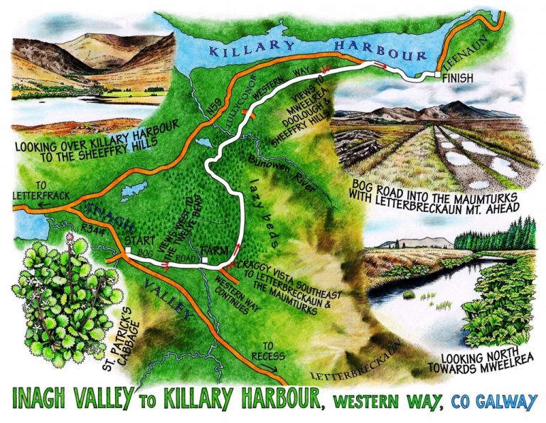
 Inagh Valley to Killary Harbour, Western Way, Co Galway
When that inevitable Martian invader demands, ‘Show me, Earthling, the best view in the romantic west,’ I’ll kit him out in a pair of walking boots (do Martians have legs? – they’d better had) and march him out along the Western Way, where it rises and curves over from the Inagh Valley to the shores of Killary Harbour. On a bright Connemara day, with sprinkling showers marching across every fifteen minutes and brilliant slabs of sunshine in between, you just cannot beat the all-round prospect of the Twelve Bens, the Maumturks and the Mweelrea range in all their majesty.
Setting off up a bog track from the Inagh valley road, it took about ten steps for the sensational beauty of these hills of central Connemara to be revealed – Benbaun and Benbrack and Diamond Hill forming the western wall of the valley, Letterbreckaun’s sharp prow the east flank, and a gleam of Lough Inagh in the south. The two mountain ranges are so dissimilar in effect – the Twelve Bens each distinct and shapely, the Maumturks one vast whaleback upheaval – but every peak glints and gleams with quartzite outcrops, like so many mirrors pocketed into the turf and heather.
Houses lie dwarfed at the feet of these mountains, adding to the lofty impression that the map heights – 729 m at the peak of Benbaun, the highest – don’t really warrant. The Maumturks in particular have a quality of wildness about them that’s palpable, though hard to pin down. Their crumpled western faces looked down blankly over the wide bogland I was crossing, where neat conical stacks of hand-cut turf awaited the tractor and trailer, and stands of half a dozen individual sods were carefully piled criss-cross to let the drying wind circulate among them. Pink rosettes of lousewort and coconut scented gorse in full yellow flower flanked the puddled bog road, whose pools of last night’s rainwater reflected the blue and grey Connemara sky.
I crossed a loudly chattering river and passed a farm with a range of sheds all knocked together out of wood and corrugated iron, simple but entirely fit for purpose. The farmer was coming up the track with his two sheepdogs.
‘Nice morning!’
‘’Tis!’
The Western Way, well marked and surfaced, swung away from the bog road and forged north through scrub of birch and willow and plantations of young green conifers. Fir trees sported long pink-brown buds at the tips of their sprigs, like strawberry chocolate Christmas candles. Up on the slopes of the Maumturks lambs cried, ‘Maaa! Maaa!’ and scampered about in search of their mothers. The faint but clear call of a cuckoo came from the edge of the plantation as a token of spring.
The forest smelt of pine resin, coconut and mint. Beside the track huge leaves of giant hogweed were unfolding, the toxic stems blistered and thorny, the flowers like bristly crimson and green bottle brushes. The stony track crossed the Glencraff River and left the trees to run along the mountainside, where the steepness of the lazybed strips and the large number of ruined houses were a stark reminder of the tough lives lived by hundreds on these long-deserted townlands.
Now the Western Way rose to the best view of all, west down the narrows of Killary Harbour under cloud-darkened Mweelrea to the humped silhouette of Inishturk lying out at sea in honey-coloured sunlight. Five minutes later it was the high, rugged bowl of Mweelrea in brilliant gold light, and Inishturk dark and stormy. A few brief words with Scott and Christine from Chicago – the picture of glowing health and youthful love, starting out to walk the Western Way as lightly and hopefully as any yellow brick road – and then I followed the old track down to where Leenaun lay along the steel-blue inlet under the green elephant backs of the mountains.
WAY TO GO
MAP: OS of Ireland 1:50,000 Discovery Sheet 37; downloadable map/instructions at discoverireland.ie/walking or irishtrails.ie.
TRAVEL: R334 Recess road off N59, 9 km from Letterfrack and 11 km from Leenaun; in 2 km, park carefully where bog road crosses R334 (with houses on right under Minnaunmore mountain).
WALK DIRECTIONS: Turn left (east) along bog road towards Maumturk Mountains. In 2 km (1.5 miles) pass farmhouse; in 200 m, where Western Way fingerpost points on ahead, turn left over a stile and follow Western Way (yellow arrows and ‘walking man’ symbols) for 8 km / 5 miles, crossing Glencraff River and a road at Tullyconor, to reach N59. Turn right along it for 1.75 km (1 mile) into Leenaun.
LENGTH: 12.5 km/8 miles – allow 4 hours
GRADE: Easy
CONDITIONS: Forest and bog roads; some boggy parts; boots advisable. No dogs allowed – sheep country!
DON’T MISS:
• Sensational views of 12 Bens and Maumturks from the bog and forest roads
• Views of Mweelrea, Killary Harbour and Inishturk from Western Way beyond Tullyconor
• Ancient lazybed ridges that stripe the mountains around Killary Harbour.
REFRESHMENTS: Hamilton’s, Leenaun (095-42234); seafood chowder, soup and toasties are all good.
PICNIC SPOT: By the Western Way overlooking Killary Harbour
ACCOMMODATION: For walking the Western Way in mid-Connemara – Nonaím Lodge, Glann, Oughterard, Co Galway (085-763-4830; fishingcorrib.com) – peaceful, comfortable, stunning views of Lough Corrib.
WALKING in IRELAND: Walking tour operators, local walks including Discover Ireland’s National Loop Walks, walking festivals throughout Ireland: discoverireland.ie/walking and coillte.ie
BOOK: Christopher’s book Walking in Ireland (Ebury Press) contains 50 of his favourite Irish Independent walks.
INFO: Oughterard Tourist Office (091-552808); discoverireland.ie/Places-To-Go/Galway
www.christophersomerville.co.uk
csomerville@independent.ie
Words: 912