Irish Independent Walk of the Week Christopher Somerville
11 June 2011
No 99: Ballycroum Loop, near Feakle, East Clare

There’s definitely something about East Clare. This subtly seductive region of steep little pastures and river valleys, squared off with white stone walls and dotted with old-style farmsteads on twisty country lanes, is a place you can very easily fall in love with – if you happen to know it’s there. The temptation to rush on through to the well-known honeypots of West Clare – the Cliffs of Moher, Bunratty, Doolin and all – means that many who might adore East Clare’s laid-back delights never even get to see them from a speeding car, let alone put the boots on and savour them properly at two miles an hour. The Ballycroum Loop in the back hills above Feakle might have been invented specifically to give an in-a-nutshell snapshot of what the district has to offer.
On the whole, I think the mistiness of the morning that Jane and I chose for the walk was a bonus. At the time it seemed frustrating not to get the long view. Who knows, from the heights of Ballycroum bog we might have been able to see the Galtees or the Slieve Aughtys, the Ballyhouras or Tir na nÓg. But the mist was down, and all we could do about it was to follow the waymarks of the East Clare Way among the white walls of vapour and concentrate on what was under our noses. When you’re walking unspoiled blanket bog studded with ancient tombs and a secret richness of wildlife, that’s the very best thing to do.
Sphagnum moss shone green and scarlet with an eerie muted light. Heather stalks as coarse and tough as leather supported flowers that had been crisped dry by wind, sun and frosts. Great mats of pale green reindeer lichen infiltrated the miniature forest of the heather, and spider threads sagging with dew pearls hung in the branches in their thousands.
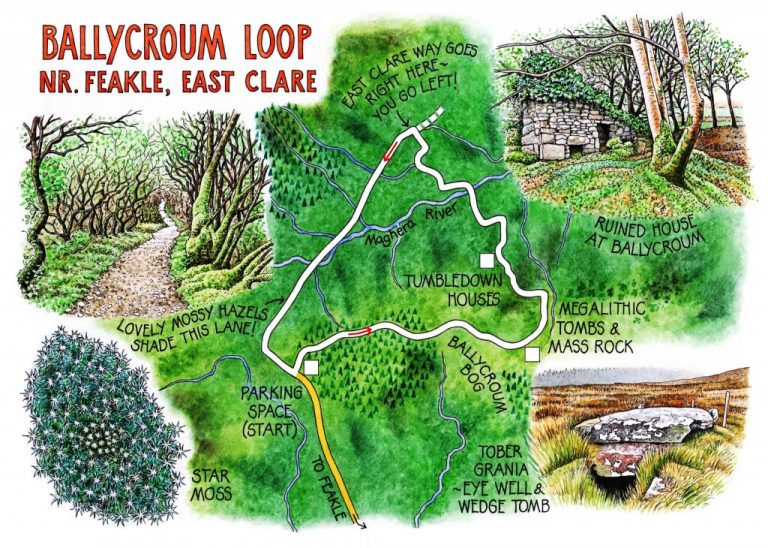
Following the little yellow ‘walking man’ logo of the East Clare Way, backed up by the all-seeing magic eye of our Satmap GPS device, we went over low ridges and down through mist hollows. All of a sudden we came on a remarkable plateau of megalithic tombs, half a dozen of them widely scattered in a hidden place. Notices beside the structures gave us potted histories and snippets of myth about these 4,500 year old burial chambers. Here was Tober Grania, a wedge tomb complete with its capstone, where the curative water of an eye well seeped through mud in the depths of the monument. There lay another capless grave, the love-couch of Diarmuid and Gráinne. On a knoll a little way away stood the rough boulders of Altoir Ultach, a tomb used by the Ulster priest Fr Ultach as a Mass Rock in penal times, when the fastnesses of Ballycroum bog concealed clandestine worshippers from unfriendly eyes.
Moving off the moor, Jane’s sharp eyes spotted a clutch of eggs laid inside a sheep’s hoof print, a tight mass of globules shiny and blue-black, each egg the size of a mouse’s eye, perhaps two hundred of them. Who or what could have laid them? Spiders? Slugs? We could only stand and speculate.
Over a stile, out of the bog, and down into the deep green valley of the Maghera River. We followed a beautiful green lane past the ruin of an old house in an ash grove, tottering under ferns and brambles with its back against a bank, holding that strong but indefinable sense of peace that such places carry along with their poignancy.
We skirted a farm where a bull was bellowing fit to bring its shed down, crossed the Maghera in a mossy dell, and passed along another green lane between banks of violets and primroses. A stream tumbled beside us, loudly chattering. Two horses, a white and a chestnut, grazed under a mountain slope. The sun began to slip through the misty clouds at last, showing us distant hills and glints of loughs. This East Clare walk could have gone on for ever, and we’d never have tired of it.
WAY TO GO
Map: OS of Ireland 1:50,000 Discovery Sheet 58; map and instructions downloadable at discoverireland.ie/walking.
TRAVEL: M7 to Jct 27; R474 to Killaloe, R463 to Tuamgraney; R352 to Scarriff; R461 to Feakle. Follow ‘Limerick’ out of Feakle, in 3.5 km, right at crossroads (‘Mass Rock, Trailhead’). In 2 km, parking space on right at forest entrance.
WALK: Follow forest road; in 1 km, left (‘Mass Rock’; East Clare Way yellow walking man and arrow/ECW; purple arrow/PA) out of trees, across Ballycroum bog. Follow ECW and PA past Mass Rock and megalithic tombs for 1 km. Right over stile (ECW/PA) out of bog; descend path; left (ECW/PA) down to road. Left for 200m; right (ECW/PA) down field edge; cross Maghera River by footbridge; up field edge into green lane. Left (ECW/PA) for 0.8 km. At tarred road by a farm ECW goes right, but turn left here (PA). Follow lane and Pas to recross Maghera River; steeply uphill on stony lane; at T-junction, left to car.
LENGTH: 5½ miles/9 km – allow 3 hours
GRADE: Moderate
CONDITIONS: Forest tracks, bog path, green lane. Wet and muddy parts.
DON’T MISS
• Mass Rock
• Megalithic tombs on Ballycroum bog
• Tumbledown houses in the green lanes
REFRESHMENTS: Picnic
ACCOMMODATION: Clareville House, Tuamgraney (061-922-925; www.clarevillehouse.net) – walker-friendly, helpful, efficient B&B.
WALKING in IRELAND: Walking tour operators, local walks including Discover Ireland’s National Loop Walks, walking festivals throughout Ireland: www.discoverireland.ie/walking.
BOOK: Christopher’s book Walking in Ireland (Ebury Press) contains 50 of his favourite Irish Independent walks.
INFORMATION:
Tourist Office: Arthur’s Row, Ennis (065-682-8366); www.shannonregiontourism.ie
csomerville@independent.ie