Irish Independent – WALK OF THE WEEK – Christopher Somerville
12 December 2009
38. Barnavave, Cooley Peninsula, Co. Louth

No wonder wild Queen Medbh and her army from Connacht pitched camp in the hidden valley under Barnavave, high above Carlingford Lough. They must have totally exhausted. They’d been up and down and round and about the Cooley Peninsula, searching for the elusive and ferocious Brown Bull, losing men to tempests, accidents and the strong right arm of Cúchulainn. So the Táin Bó Cuailnge tells us, at all events. That great epic is rather coy on the subject of the weather at the time, but no doubt rain fell and mist ribboned around the Cooley mountains, then as now.
Rain and mist were certainly much in evidence today, hanging threateningly over Carlingford Lough and drawing a veil between the shores of the Republic and those of Northern Ireland. With Aude Laffon and her husband Peádar as guides, philosophers and field archaeologists, Jane and I didn’t really care. In the company of this young and enthusiastically knowledgeable couple, every dripping stone and foggy hilltop would have a tale to tell.
You could easily set off for a walk from Carlingford and never even leave the neatly white-washed town with its craggy old castles, its conversational shops and steamy-windowed pubs. It was a temptation to crowd the table in P.J. O’Hare’s with pints, and let the hills go hang. But there was something fine about being the only souls out and about. The fuchsia bushes clinked silently with rain diamonds along the granite walls of the steep green lane above the town, and Slieve Foye hid its rugged face behind a gauze of mist as teasingly as any witchy queen of legend. Turning round for the view at the saddle of Golyin Pass, we watched the Mourne Mountains across Carlingford Lough change from milky green to a gauzy, moth-wing grey as the oncoming rain brushed them up in its skirts. A minute more and we had changed, too, from dry humans to glistening seals.
Looking west from the gap over the landscape of that earth-shaking struggle of arms and wills between Medbh and Cúchulainn, everything looked as insubstantial as a dream. Cloud curtains closed and opened between us and Windy Gap, gouged out in three days by Medbh’s army as a gesture of contempt for Ulster. Rain seethed through the shallow valley of the River Cronn where famed Ualu drowned under his flagstone, and hundreds more Connachtmen with him. Even the peak of Barnavave, when we threaded the steep pass beneath it where queen and cohorts had camped, stood misted out of sight. Yet the old tale still held its magic.
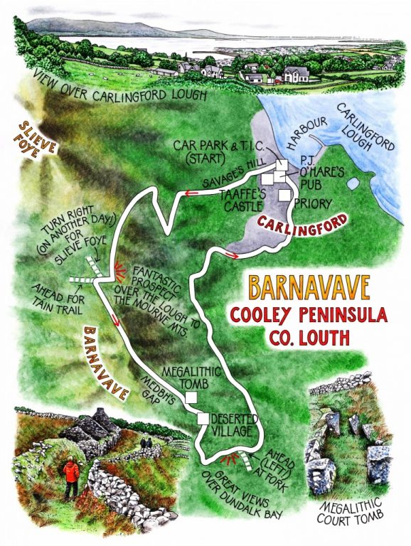
Down in throat of Medbh’s Gap, as the rain began to fade off westward, we found an alignment of mossy stones in the crook of a wall. ‘A court tomb,’ Peádar said. ‘But a very unusual one – it has two courts, one each end, see?’ The two crab-claw shaped courts, perhaps built for funerary ceremonies, once guarded a great tomb with five internal chambers. It must have been a strong imperative that led hard-pressed subsistence hunters to build such a structure almost 7,000 years ago. How different were their lives, we wondered, from those pursued only a few decades ago in the abandoned village that lay a little way down the slope?
The stone-built houses stood roofless, huddled together along a tangle of cobbled lanes and bracken-smothered, ridged potato fields walled in against the salt wind and rain off Dundalk Bay. Fireplaces, stone-lined cupboards, a dog kennel delved into an outside wall – here were the intimate furnishings of a whole community, irrevocably wiped away. I followed the others down the lane towards Carlingford, picturing that vanished society, as far removed from our technological, hard-sell way of life as any brave old legend.
WAY TO GO
MAP: OS of Ireland 1:50,000 Discovery 36; downloadable map/instructions (highly recommended) soon to be available at www.discoverireland.ie/walking.
TRAVEL:
Bus: 161 Dundalk-Newry (www.buseireann.ie); 502, 701 (www.louthlinx.com)
Road: M1 to Dundalk; R173 to Carlingford. Main car park by Tourist Information Centre.
WALK DIRECTIONS: Walk past Taaffe’s Castle to town square; up Savage’s Hill (to right of Savage’s Butchers). Where tarmac ends, ahead up walled green lane. Halfway up hill, track passes through gate on left and continues upward as green path. Turn right up Táin Way when you meet it (yellow ‘walking man’ marker). At pass, ‘Slieve Foye’ marker points right. In 50 m, Táin Way ‘walking man’ arrow points ahead; left here up fence towards Barnavave. Keep fence, then wall on right; steeply down Medbh’s Gap. 50 m below left-right dogleg, right through wall (Court Tomb lies uphill in angle of wall). Path bears diagonally downhill to deserted village. Follow wall to right, then left by houses down walled lane. In 50 m, right between walls; in 100 m, right through wall; descend; left along lane. In ¼ mile, ahead (not right!) at fork; continue ¼ mile to tarmac road; left to Carlingford.
LENGTH: 5 miles: allow 3 hours
GRADE: Moderate/Hard
CONDITIONS: Hill paths and tracks.
DON’T MISS … !
• views from saddle over Carlingford Lough to Mourne Mountains
• megalithic tomb in Medbh’s Gap
• deserted village
REFRESHMENTS: P.J. O’Hare’s, Tholsel Street, Carlingford (042-937-3106; www.pjoharescarlingford.com)
ACCOMMODATION: Beaufort House, Ghan Road, Carlingford (042-937-3879; www.beauforthouse.net)
GUIDED WALKS: Contact Aude Laffon (0871-335159; www.setantatours.com)
INFORMATION: Walking tour operators, local walks including Discover Ireland’s National Loop Walks, walking festivals throughout Ireland: www.discoverireland.ie/walking; www.coillteoutdoors.ie
Glen of Aherlow Winter Walking Festival, Tipperary: 29-31 January (info: www.aherlowhouse.ie)
INFORMATION:
Carlingford Tourist Office: 042-937-3033; www.carlingford.ie
csomerville@independent.ie