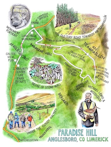
‘Here we are in Gleann-na-gCreabhar, the Glen of the Woodcocks,’ said Michael Lewis, reaching inside his bag. ‘So …’ and with a flourish he pulled out a woodcock, a real one, sleek and beautiful on its taxidermist’s stand.


We all gasped and grinned – Jim Flynn, Fergal Somers, Jane and myself – at this magician’s sleight of hand. Perhaps we should have expected something of the sort. When you’ve taught the children of Anglesboro, and their children, for 38 years, as Michael did, you’re bound to have a little something up your sleeve to tickle the imagination of your audience.
Michael knows, better than most, the farms and farmers, the laneways and hills of this north-west corner of the Galty Mountains. Jim has the same knowledge and feel for the neighbouring Ballyhoura hills. And Fergal is a new broom brought in to sweep some energy and imagination into the leisure activities of both mountain ranges, which saddle the borders of Limerick and Tipperary. Setting off up Paradise Hill with the three of them felt like a walk with a gathering of tutelary spirits.
Fieldfares were hopping in the ash trees as we followed the lane out of Anglesboro. ‘A great sign of winter,’ said Michael. ‘I love to see them.’ Standing stones rose weathered and stumpy in the fields, which ran in neatly hedged rectangles down to the rushy townland of Barnagurraha. Liam Lynch was born in a house down there in 1893, and died 29 years later in the Knockmealdown Mountains as IRA Chief of Staff, shot in a gun battle. A tall monument by the roadside showed his likeness, a thinker’s face above a simple line: ‘Your epitaph is your glorious service, Liam.’
Up on the steep hillside above the village we paused to look out north and west across an immensity of small fields and woodland patches, the Glen of Aherlow running away to the north-east under the sloping hummock of Slievenamuck. Michael pointed out the long straight line of a famine road, its course cutting as straight and artificial as a die across the grain of the landscape.
We climbed on up Paradise Hill by way of a precipitous old turf road. Local men once inched down here the rough sleds on which they brought the dried turf down from the turbary slopes of An Teampaillín, the ‘mountain of the little temple’ that looms over Paradise Hill. A turn of the forest road brought us a southward view down through a vee-shaped cleft to Mitchelstown, the pale patch of the town’s enormous Aldi distribution centre as large and reflective as a lake.
The Celestial Scene-Shifter had been busy piling up grey clouds in the west, and now turned his attention to Paradise Hill. As we reached the summit of the walk under An Teampaillín the mist slid across and the rain and wind came hammering in on its coat tails, setting the hill streams gurgling and making me wish, as so often, for patent windscreen wipers on my spectacles.
We climbed a stile and skeltered down the eastern face of the mountain, slipping in damp green sphagnum patches; then back down the muddy old turf road with Michael throwing out snippets of local history and legend – ‘That field once changed hands for a bag of meal and an overcoat… They used to cut the young furze, pound it up with a heavy spade and feed it to the horses… A local saying about the worth of land was, “Gold under furze, silver under rushes, famine under heather”.’
Talking and laughing, we went on down the slopes of Paradise Hill. The ground mist came creeping at our heels, while high above us the shoulders of An Teampaillín shrugged themselves free of the cloud at last to give us a glimpse of the mountain’s beautiful, cairn-crowned head.
WAY TO GO
MAP: OS of Ireland Discoverer 74; downloadable map/instructions at discoverireland.ie/walking.
TRAVEL: M8 Jct 12 to Mitchelstown; R513 towards Kilfinane; in 2 km, R513 (‘Ballylanders’); in 4 km, right to Anglesboro. Park at trailhead – Community Centre car park on right.
WALK DIRECTIONS: Ahead past Galtee View pub and Lane’s shop. Follow road (‘Paradise Hill Loop’; green arrows/GA). In 1.5 km, opposite farmhouse on left with green corrugated gates and buildings, fork right through gate (GA) up zigzag track. On 2nd left bend, ahead up hedge (GA). Over ladder stile at top; right along forest path, ascending to a summit, then descending. Below Temple Hill, right (GA); in 100m, right (GA) on stony track. In 1.5 km, Benard Loop turns right (purple arrow), but keep ahead here (‘Paradise Hill’, GA). In 400 m, left (PA, GA) on stony track up to summit and on down. In 1.5 km, on left bend, cross stile (GA) onto open mountain. Left downhill beside fence. At bottom, left over stile (GA); right along track; retrace outward course to Anglesboro.
LENGTH: 12.5 km/7½ miles – allow 3-4 hours
GRADE: Moderate
DON’T MISS:
View from Temple Hill north-east up Glen of Aherlow
View south over Mitchelstown and Knockaceol, and west to the Ballyhouras
REFRESHMENTS: Picnic (from Lane’s shop, Anglesboro); drink at Galtee View pub, Anglesboro.
BEST PICNIC SPOT: Slopes of An Teampaillín
ACCOMMODATION: Deebert House Hotel, Kilmallock, Co. Limerick (063-31200; deeberthousehotel.com; from 75 euros dble B&B, special offers available).
GUIDE LEAFLETS: National Loop cards from Ballyhoura Failte TIC, Main Street, Kilfinane (063-91300)
INFORMATION: Walking tour operators, local walks including Discover Ireland’s National Loop walks and walking festival: discoverireland.ie/walking.
Ballyhoura Walks Festival information www.ballyhouracountry.com
Paradise Hill Looped walk – information
http://www.discoverireland.ie/Activities-Adventure/paradise-hill-loop/80868