 Irish Independent – WALK OF THE WEEK – Christopher Somerville
26 September 2009
No. 27. Windy Gap, Iveragh Peninsula, Co. Kerry
‘We are wet outsides and we are wet insides,’ grinned the two flaxen-haired German girls in the lane outside Glenbeigh. Their sopping waterproofs, quite patently, were nothing of the sort. Sean O’Suilleabhain and I nodded back sympathetically as the latest of this day’s downpours bounced off our backs.
It has certainly been a bloody old summer, all right. But I would have braved far worse than a bit of a soaking for the chance to cross Windy Gap with the self-effacing gentleman whom Lady Fortune had put in my way today. If you’re lucky enough to have Sean O’Suilleabhain as a walking companion through County Kerry, then you’re lucky indeed. This modest and gently humorous man, the founding father of the Kerry Way long-distance footpath, is a fountain of fact and fiction concerning his beloved native county.


Gale force winds were forecast to sweep in across the Iveragh mountains, dragging much of the Atlantic in their skirts. In the event we beat them to it, and were rewarded by some of the finest far prospects in Ireland, a full palette of subtle colour and vigorous movement – mountains smoking with cloud and rain, foothills and shores muted into slaty shades of blue and grey, the sea a mass of curved white shark’s teeth as it surged landward through the channels and sandspits of Dingle Bay.
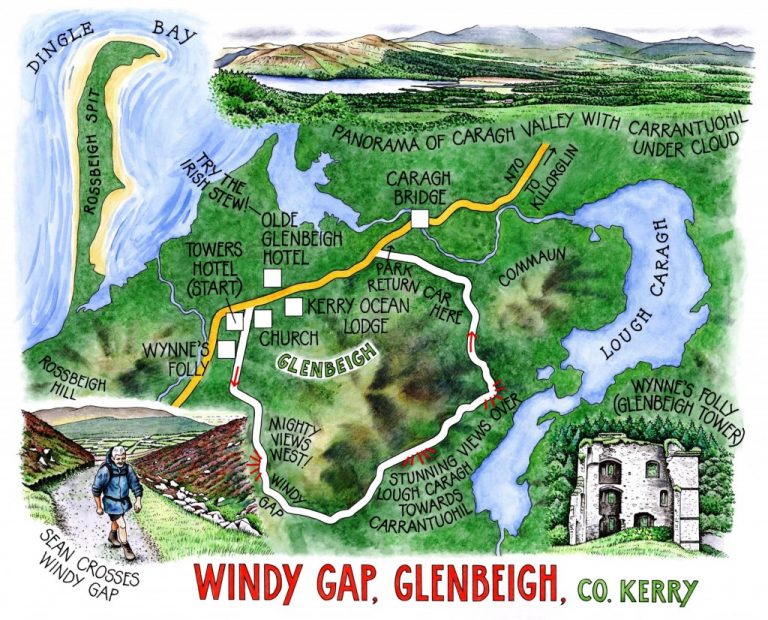
The stark shell of Glenbeigh Tower stood a field away as we started along the lane. ‘Wynne’s Folly,’ murmured Sean. ‘Built by Lord Headley Wynne in the 1860s to please his wife, and paid for by increasing the rents of his tenants. Those who couldn’t find the extra money were evicted.’ He sighed. ‘A familiar story, and a scandal which reached the House of Commons.’
From the zigzag path up to Windy Gap we looked back west where the whaleback of Rossbeigh Hill, dull gold in its coat of wet gorse flowers, framed the long promontory of Rossbeigh Spit reaching out across the mouth of Castlemaine Harbour towards the spit of Inch. ‘Oisin caught his giant wave there on Rossbeigh Spit, and surfed it on out to Tir na nOg,’ said Sean. Wind-driven rollers broke in spray on the twin opposing strands as we watched, not quite mighty enough to transport a hero, perhaps, but a fine sight nonetheless.
It was windy at Windy Gap, a good shoving half-gale that got well behind us and pushed us on down a wide stony track – the old main road from once-populous Glencar out to the coast and the church at Glenbeigh, Sean told me. I had eyes only for the forward view now, a stunning prospect over Lough Caragh lying quiet and sheltered in its dreamy wooded valley, brushed by bands of sun-silvered rain. All round the valley rose a protective ring of mountains. Sean ran his eyes along their flanks and ridges like a man counting treasure.
Up ahead beyond the lake stood the huge hanging valley of the Coomloughra Horseshoe, dark and thunderous under the cloud-obscured peak of Carrantuohil. ‘Ireland’s highest mountain at 3,406 feet,’ observed my companion, ‘and I used to take schoolfriends up there as a kid from my uncle’s house in the Brida Valley. That’s where I must have got my love of walking and the outdoors from, but I really didn’t know what I was doing back then. I couldn’t even read a map and compass! Somehow I survived, though.’
Indeed he did. Lovers of County Kerry’s great wild spaces owe a huge debt to Sean O’Suilleabhain and his fellow walkers, who have kept so many old green roads open with such persistence and energy. Coming off the mountainside and down the road under the wrinkled flanks of Commaun towards the tumbling sea in Dingle Bay, I smiled to myself at the thought that there might still be heroes in Kerry after all.


WAY TO GO
MAP: OS of Ireland 1:50,000 Discovery 78; downloadable map/instructions at
http://tcs.ireland.ie/dataland/TCSAttachments/341_TheKerryWay.pdf
TRAVEL: N70 from Tralee or N72 from Killarney to Killorglin; N70 to Glenbeigh. For 2-car walkers, park one car neatly up side road off N70, ¼ mile west of Caragh Bridge, and drive other car on for ¾ mile into Glenbeigh. Park near Towers Hotel in Main Street.
WALK DIRECTIONS: By Towers Hotel turn up road past church (Kerry Way/KW ‘walking man’ waymark post). In ⅓ mile take first lane on left (KW). Follow KW to end of tarmac, then up track to cross Windy Gap and descend to 3-way fingerpost. Keep ahead (‘Scenic Route’) to reach road and follow it down to N70 and return car near Caragh Bridge.
LENGTH: 6 miles: allow 3 hours
GRADE: Moderate
CONDITIONS: Good tracks and country roads
DON’T MISS … !
• ruin of Wynne’s Folly
• wonderful views over Dingle Bay from Windy Gap
• stunning vista of Caragh Valley and Lough, backed by Carrantuohil, from old road beyond Windy Gap
REFRESHMENTS: Olde Glenbeigh Hotel (066-976-8333; www.glenbeighhotel.com) – real home cooking
ACCOMMODATION: Kerry Ocean Lodge (066-976-9666; www.kerryoceanlodge.com) – from €50 dble B&B. First-class hostel style accommodation; very helpful and friendly
GUIDE BOOKS/LEAFLETS: The Kerry Way by Sandra Bardwell (Rucksack Readers)
OPERATORS/COMPANIES: Go Ireland (066-976-2094; www.govisitireland.com)
offer guided walks
INFORMATION: Walking tour operators, local walks including Discover Ireland’s National Loop Walks, walking festivals throughout Ireland: www.discoverireland.ie/walking; www.coillteoutdoors.ie
NATIONAL TRAILS DAY 2009: Sunday 4 October (www.nationaltrailsday.ie)
NB – Burren Peaks Walking Festival (www.burrenpeakswalkingfestival.com): 25-7 September 2009
INFORMATION: Tourist Office: Iveragh Road, Killorglin (066-976-1451); http://www.discoverireland.ie/Southwest.aspx
csomerville@independent.ie