There’s wet weather, and there’s rain, and there’s a soft sort of a day. And then there’s the kind of a day that can come seething across the borders of Sligo and Roscommon – cold, wind, a running sky, and bursts of whatever it is that lies between rain, mist and the bloody nuisance of a moisture that has you pulling your anorak hood back and forth, your zip up and down, your backpack on and off.
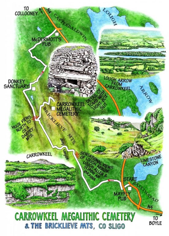
A day in the car, sulking and steaming up the windows? Or a day in the Bricklieve Mountains, walking the Historic Trail from Ballinafad to Castlebaldwin, exploring the megalithic mysteries of the passage graves at Carrowkeel, getting a few miles and a good soaking under our belts? Well, no contest … we put on the rain armour and got out there, trudging from Ballinafad up a stone-walled boreen thick with ragged robin and bramble flowers.
Cattle bellowed from the green hummocky hill of Maelahoo, sheep cropped the waterlogged fields with that immemorial sheepy patience in adversity, and raindrops hung fat and pendulous from the honeysuckle flowers in the hedges. Close inspection showed the holes in the rust-orange tin roofs of hard-to-work hill farms left to the rain and wind, a sign of our times. We stopped at the crest of the boreen to look back over Ballinafad tucked around its stream running down through trees to Lough Arrow, a maze of wooded promontories. Beyond it in the east Lough Allen glinted at the foot of Sliabh an Iarainn, a pale bulk under clouds drifting crabwise with their heavy freight of rain.
The boreen gave onto an open hillside of lush grass and tall thistles, where the path snaked around before dipping into a great canyon walled with pale limestone cliffs, unsuspected until we were on its brink. Down in the bottom of the cleft were tiny fields that had once been worth someone’s while to wall off carefully one from the other, now abandoned to heath spotted orchids and clumps of eyebright. Up on the far rim of the canyon our track wound among peat hags before settling for a hard-surfaced northward course through the heart of the Bricklieve Mountain – uplands, really, with gently domed tops where our ancestors built the fabulous necropolis that we now call Carrowkeel.
The northern edge of the Bricklieve range juts out into the south Sligo lowlands in a series of prows, each with its round tomb as a focal point. At Carrowkeel they are concentrated on the hilltop, 14 passage graves with stone lintels and kerbs under vast mounds of limestone rubble. One of the first we explored had a double lintel, the upper one framing a slit to admit a gleam of setting sun at midsummer solstice. You can see exactly why primitive people – any people with a deep connection to their landscape, for that matter – would bury their great ones up here, close to the sky and dominating the world with those pale stone mounds standing high. Maybe they were not even great ones – who can know, at this remove?
The rain sifted and spat across Carrowkeel. We crouched in the doorway of one of the cairns, speculating and conjecturing, until white curls of mist began to drift into the necropolis and creep round the cairns. It was time to take the downward path. As we came down from the cairns the mist drew back, the rain swept off southward, and a forty-mile view sprang out of nowhere – Ox and Dartry Mountains, lakes, fields, woods and towns, all honeyed in sunlight like a gift you never expected, suddenly laid right at your feet.
WAY TO GO
MAP: OS of Ireland 1:50,000 Discovery 25, 33; downloadable map, instructions from irishtrails.ie.
GPS: Satmap.com
TRAVEL: Bus (buseireann.ie) service 23 (Dublin-Sligo) to Ballinafad.
Road – Ballinafad is signed off N4 between Boyle and Collooney.
Return from Castlebaldwin to Ballinafad by bus, 2-car trick, or Boyle Taxis (087-610-5111, 086-176-8681).
WALK DIRECTIONS: From Ballinafad go under N4; immediately right along lane beside N4; first left up hill road. In 1.25 km/¾ mile, opposite farmyard on left, right up gravel lane (Historical Trail/HT logo of walking man). Lane soon becomes walled boreen; follow it and HT uphill for 1.5 km/1 mile. At top, bear left out of boreen; follow HT across ravine; up far slope, over stiles and on across open moor on clear track for 1.25 km/¾ mile to right turn signed ‘Carrowkeel’. Detour to megalithic cemetery; return to HT. Continue to T-junction; turn right (HT). In 0.7 km/ ½ mile, at gate of donkey sanctuary, left over stile; follow HT through fields, then ahead along lane for 1.5 km/1 mile to T-junction. Right into Castlebaldwin.
LENGTH: 8½ miles/13.7 km – allow 4-5 hours
GRADE: Moderate
DON’T MISS…
• Views east over Lough Arrow, Lough Key, Lough Allen and Sliabh an Iarainn
• Carrowkeel megalithic cemetery
• Donkey sanctuary
REFRESHMENTS: McDermott’s pub, Castlebaldwin (071-916-5132) for soup and sandwiches, or Mayfly pub in Ballinafad (071-966-6198).
PICNIC SPOT: Carrowkeel megalithic site (always open)
ACCOMMODATION: Frances McDonagh, Lough Key House, Boyle (071-966-2161; loughkeyhouse.com) – from €84 dble B&B (2 weekend nights + dinner, €113 pp). Wonderful hospitable house, sensational breakfast (home made bread, superb marmalade and jam, etc).
WALKING in IRELAND: Walking tour operators, local walks including Discover Ireland’s National Loop Walks, walking festivals throughout Ireland: www.discoverireland.ie/walking and www.coillte.ie
BOOK: Christopher’s book Walking in Ireland (Ebury Press) contains 50 of his favourite Irish Independent walks.
INFORMATION: Boyle Tourist Office (071-966-2145)
csomerville@independent.ie
Words: 910