Irish Independent Walk of the Week Christopher Somerville
12 March 2011
No. 87: Cullahill Mountain and Binnianea Forest, Co. Laois/Co. Kilkenny

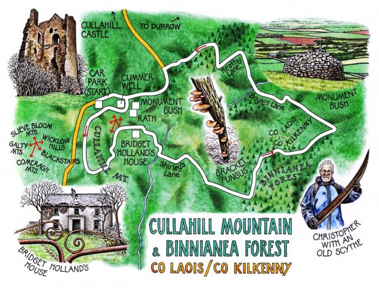
‘My father would have brought the cows up and down this path,’ observed Vincent O’Sullivan, pointing up the slope of Cullahill Mountain. The narrow track, newly provided with steps by workers of the Rural Social Scheme, rose steeply through the bare hazel woods – more steeply than one could imagine a clumsy herd of cattle negotiating safely. Up it climbed the merry men and women of Co. Laois who’d come out to show us their favourite walk – Noel Mooney and Ann Lanigan, Kieran Holland and G. Phelan, and brothers Vincent and Liam O’Sullivan, organic farmers and dedicated enthusiasts for their native countryside.
At the crest of the mountains the wind blew cold and harsh. The Slieve Bloom mountains in the north-west veiled their charms under smoking, slaty clouds; so did the Comeraghs and Galtees away in the south-west, the Blackstairs and Wicklow Hills to the east. ‘You’ll have to come back on a beautiful day in summer and take it all in,’ said Ann Lanigan. But we didn’t begrudge the Clerk of the Weather his sulks today.
‘A monument bush,’ said Liam O’Sullivan, indicating a cone of dry stones enclosing an ancient whitethorn. ‘There’s precious few of these in Ireland. It’s to commemorate Cormac Fitzpatrick of Cullahill Castle – you see it there below.’ The broken tooth of the castle stood up from chequerboard fields. ‘Fitzpatrick wouldn’t submit when Cromwell’s men came, so they sacked the castle, chased him up here and cut him down with swords.’
Near the monument rose the shaggy walled mound of a rath, its wind-crippled thorn trees footed in a scurf of neatly nibbled shells where pigmy shrews had feasted on the kernels of haw berries. We walked the high curve of Cullahill’s escarpment and dropped down into a crooked roadway. The mossy remains of houses, half hidden in the ash thickets, lay long abandoned – but not so long that their former inhabitants had faded out of local memory.
‘Bridget Holland,’ mused Liam, his hand on a curlicued gate. ‘People would come here to play cards. There was always a great smell of currant bread, and she’d a name for the best apple pie anywhere around.’ A tight cluster of empty cottages behind Mrs Holland’s house held empty fire grates, stone flagged floors, a rusty scythe blade, a scatter of pig’s knuckle bones hidden in the roof lintel. ‘Murphys and Whelans lived here. Murphy would come in, take off his boots, put his feet up on his wife’s lap, and she’d darn his socks for him, still on his feet.’
On into Co. Kilkenny and cloud-topped Binnianea Forest. Deep among the trees we found the tumbledown house where the O’Sullivans’ grandfather had been born, seventh son of a seventh son. His own son was a curer of toothache – an inconvenience at harvest time, said Liam, because of the interruptions that swollen-cheeked sufferers would cause as they came begging for a touch of his healing hands in those pre-Health Service days.
Back in County Laois we passed the new house being built where Zulu Murphy had once farmed (he’d served in the Boer War), and descended an old walled mass path. Only a generation ago, the farm wife had climbed this boreen daily from the milking pastures below with a full bucket on her head, balanced on a pile of her own waist-length hair. A haunting and poignant image to carry from the mountain to the wider world below.
WAY TO GO
MAP: OS of Ireland 1:50,000 Discovery 60; downloadable map/instructions (highly recommended) at www.discoverireland.ie/walking.
TRAVEL:
From Durrow, N8 Cork road. In Cullahill, pass Sportman’s Inn; in 50m, left on L1756; right at castle, and follow ‘Trailhead’ to car park and map board.
WALK DIRECTIONS: From car park, right down road. In 200m, right (purple arrow/PA) up steps through woods. At top, cross stile out of trees. Pass Cummer Well on your right; in 200m, at PA post pointing right, detour left to rath and monument bush; then return to PA post and follow PAs along hillside and over ladder stile for ¾ mile to road. Left (PA) for ⅔ mile; right along Shirley’s Lane (PA). Follow lane for ⅔ mile; just before gate across it, left (PA) through gate, across field into Binnianea Forest (PAs and white markers). Ahead for 100m; left on forest road (PA) for 700m; left (PA) through trees to cross stream. Field paths (PAs) to Boyles Lane. Left along lane for ⅔ mile, crossing stream and ascending to cross stile. Left (PA) along Heathy Lane for 300m; right over stile (PA) through forest (PAs) for ⅔ mile, down steps and walled lane to road; left to car park.
LENGTH: 7½ miles: allow 3-4 hours
GRADE: Moderate
CONDITIONS: Field paths, forest tracks, lanes. Some muddy bits! Some steep steps.
DON’T MISS … !
• monument bush and rath
• views of many hill ranges from Cullahill Mountain
• poignant ruins of former farmsteads
REFRESHMENTS: None en route – take a picnic. In Durrow, Bob’s Bar by the bridge (057-8736630) – don’t miss bygones exhibition and bicycle museum!
ACCOMMODATION: Ashbrook Arms Townhouse, The Square, Durrow, Co. Laois (057-874-0989; ashbrookarms.com) – beautifully kept, family run and very friendly.
WALKING in IRELAND: Walking tour operators, local walks including Discover Ireland’s National Loop Walks, walking festivals throughout Ireland: discoverireland.ie/walking.
Millstreet Hillwalking Festival. Co. Cork, 9-10 April: contact Michael Thornton on 086-172-1142; http://walkersassociation.ie/node/35797
Co. Laois Walking Festival throughout July (17 walks in14 locations):
http://laoispartnership.ie/general-news/2010/06/laois-walks-festival-steps-out/
INFORMATION:
Portlaoise Tourist Office: James Fintan Lawlor Avenue (057-862-1178; laoistourism.ie)
csomerville@independent.ie