Irish Independent – WALK OF THE WEEK – Christopher Somerville
12 June 2010
62. Ness Country Park, Co. Derry

The countryside of County Derry goes unexplored by most visitors as they dash on through to Derry city or up to the sands of Benone. That’s a shame, because it’s great walking country – especially in the narrow wooded glen of Ness Country Park, just south-east of Derry, that forms the gorge of the Burntollet River. A dramatic burst of floodwater from a melting glacier cut the gorge through the ancient rocks ten thousand years ago. Nowadays the Burntollet drops in a spectacular fall in the heart of Ness Wood, before snaking and sparkling in a rocky bed down the valley bottom and on through neighbouring Ervey Wood. There are buggy and wheelchair friendly paths here, high tracks through the flowery woodland, and flights of steps to give the old knees and lungs a good work-out.
The recently opened Visitor Centre (run with great enthusiasm by park ranger Stewart Molloy and assistant warden Seamus Carten) is very family-friendly, with stuffed animals and hands-on activities for the kids, and fascinating displays that explore the story of the glen. Ness and Ervey Woods are rare survivals of ancient forests that once covered the land. Less than one acre in a thousand of Northern Ireland’s ancient woodlands survived the axes of millennia of shipwrights, charcoal burners, tanners and house builders; but the woods that now flourish in Ness Country Park were on land too steep for the cutters to get at them. These days they shelter a wonderful variety of wildlife. Red squirrels (rare survivors themselves) are seen in the oaks and beeches of Ness and Ervey; otters hunt salmon along the Burntollet, dippers bob on its stones; buzzards and long-eared owls quarter the valley.
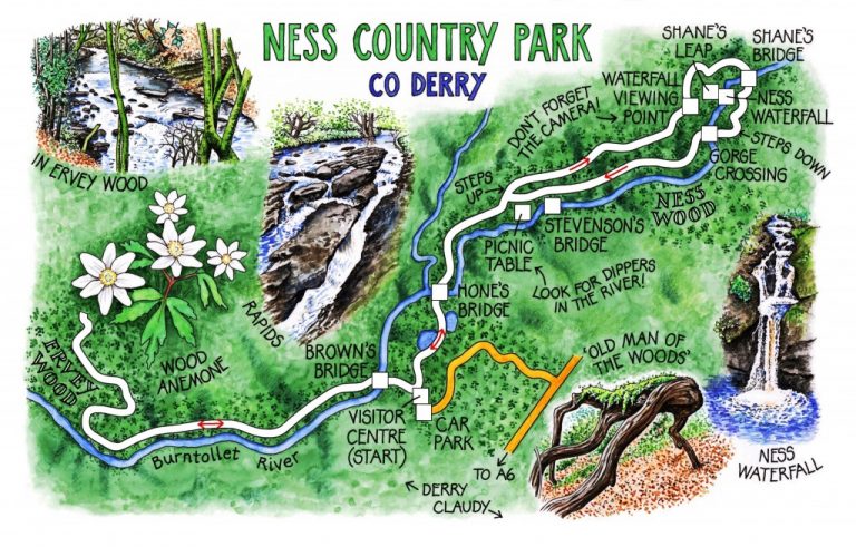
A figure-of-eight route shows you the best of the park. While Jane lingered among the displays, I started by following the path through drifts of wood anemones along the floor of Ervey Wood. The gravelly track shadows the shallow Burntollet, its pure water charged with oxygen bubbles after tumbling from the moors, then climbs on a ledge of bilberry and moss with a steep fall to the river glinting a hundred feet below.
Back at the Visitor Centre I met up with Jane, and we took the riverside path towards Ness Wood together. First a sandwich at a handily placed picnic table beside the Burntollet at the entrance to the wood; then a flight of steps and a switchback path high above the water. The way runs through groves where fallen boughs, dried and mossy-backed, look like weird old men of the woods caught in the act of scuttling off into the undergrowth.
The gorge sides narrow below, the rumble and crash of the river get louder, and then a turn in the path reveals the full majesty of the Ness Waterfall. There’s a viewing point beside the path from which you get the full panorama – the Burntollet hissing and sluicing through a glossy black rock gateway, then hurtling in slow motion (there’s no better way to describe it), a lacy fan of peat-tinted water, down into a smoking pool. Spray from the endlessly churning fall keeps everything damp, with dripping mats of mosses and liverworts overhanging the rocks.
We crossed the river above the falls at Shane’s Leap and turned back through the trees on the far bank, thinking of the handsome raparee Shane ‘Crossagh’ (‘Scarface’) O’Mullan. Whether the jolly outlaw – a great favourite with the ladies of 18th-century Derry – actually leaped the 20-foot gap across the gorge while being chased is open to question. One tale says he slipped and fell to the rocks, breaking his leg, but still managed to thumb his nose at his pursuers and get away. Another tells of how he stripped a company of soldiers and made them march into Derry in nothing but their drawers. It seems pretty certain that Crossagh was actually an unpleasant character who ended his life by doing the hangman’s jig in 1722. But who wants a good story spoiled by too much reality?
WAY TO GO
MAP: OS of Northern Ireland 1:50,000 Discoverer 7; downloadable map/instructions (highly recommended) at http://www.walkni.com/Walk.aspx?ID=205, and in leaflet guide at Visitor Centre
TRAVEL:
Signed off A6, Derry-Claudy
WALK DIRECTIONS: From Visitor Centre, cross Brown’s Bridge; left through Ervey Wood, by river and uphill; return to Visitor Centre. Cross Hone’s Bridge; where path leaves river, left up steps; higher path past Ness Waterfall. At open field, right on gravel path. Fork left to cross Shane’s Bridge. In 200 yards, right down steps; recross river (Gorge Crossing); follow lower path. At Stevenson’s Bridge, don’t cross; bear right to return to Visitor Centre.
LENGTH: 3½ miles: allow 1½-2 hours
GRADE: Easy (valley floor) to moderate (rough woodland paths, some steps)
RATINGS: 3 buggies (wheelchair accessible paths near Visitor Centre); 1 wellies; 2 binoculars; 1 mountain slopes (steps)
CONDITIONS: Very well surfaced throughout; trainers are fine
DON’T MISS … !
• Visitor Centre displays
• views of the Burntollet River
• Ness Waterfall (especially after heavy rain!)
REFRESHMENTS: Picnic (nice spot near Stevenson’s Bridge)
GUIDE BOOKS/LEAFLETS: From Visitor Centre (024-71-338-417)
NESS WOOD COUNTRY PARK:
Car park open daily: 9.30-7, March-Oct; 9.30-9, May-Aug; 9.30-4.30, Nov-Mar
Visitor Centre: 10-5, weekends and public holidays, Easter-Sep; 10-5 daily, July, Aug; 12-4, Sundays only, Oct-Easter
http://www.ni-environment.gov.uk/places_to_visit_home/parks/ness.htm
INFORMATION: Walking tour operators, local walks including Discover Ireland’s National Loop Walks and Northern Ireland’s Quality Walks, walking festivals throughout Ireland: www.walkni.com; www.discoverireland.ie/walking
INFORMATION: Derry Visitor Bureau, 44 Foyle Street (024-7137-7577; www.derryvisitor.com); www.discovernorthernireland.com
csomerville@independent.ie