Irish Independent – WALK OF THE WEEK – Christopher Somerville
29 May 2010
60. Clogher Bog. Co. Mayo

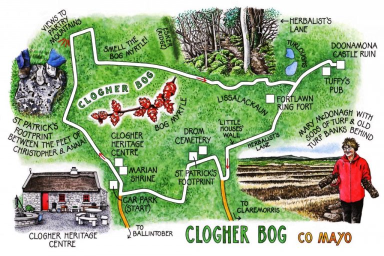
The new-born lambs in the townland of Newtown hadn’t yet grown into their wrinkly skins, which hung on them like poorly fitting home-knit sweaters. They needed their natural pullovers, too, on this sunny spring afternoon with a brisk north wind streaming across the Plains of Mayo. Jane and I smacked our gloved hands together as we set out from Clogher Heritage Centre, a working forge and a thatched cottage complete with butter churns, a proper old ‘hag’s bed’ and a cheerful fire. The cottage forms the hub of the Clogher Bog Looped Walk, a superb circular route through some of rural Mayo’s most characteristic country.
Our companions on this blowy afternoon were Anna Connor, who has been establishing new walking routes all across Mayo, and local woman-of-knowledge Mary McDonagh. ‘I work at training unemployed people,’ Mary explained, ‘and they helped the community of Clogher to develop the Heritage Centre. But then we thought: well, that’s great, but how do we attract people to come and see it? That’s how the bog walk started.’
Anyone who loves and appreciates bogland doesn’t need to be told of this environment’s subtle beauty and endless variety. But many still discount the bog as a waste of space, ugly and empty. Here’s the walk to change their minds for them.
Down in the south-west the ice-blue ridges of the Partry Mountains humped up on the flat horizon under a streaky sky – perfect targets for a well-aimed telephoto lens. Songbirds fluted from the silver birch scrub as we tramped a bog road through heather burned by a recent fire to charcoal black and brilliant orange. ‘Only a month ago people were skating on the floods out here,’ noted Mary. ‘A bog’s well able to cope with these big changes.’
Two bog horses approached out of the gorse, but their palates were too fine for the whisp of grass I held out. They sniffed it, then drew back their dark lips and snorted in disapproval. We had better luck with the old donkey at Doonamon; he put his nose over the fence to be stroked, and nodded vigorously as though to say: ‘OK, but where’s the sugar lump?’
By the ancient ring forts of Fortlawn and Lissalackaun a massively thick wall crossed the fields. Built by a farmer, Mary said, from the stones of some ancient houses he’d knocked. And the names of the families who’d lived there? ‘Morning, Noone and Knight,’ she recounted, ‘Rabbitte, Fox and Hare! Strange, but true!’
Information notices fixed to trees along the Clogher Bog walk give fascinating snippets of folklore. Alder’s unlucky; a hazelnut in your pocket guards against the rheumatics; whitethorn’s a fairy tree that can harm those rash enough to abuse it. Not so long ago every country man and woman knew these things, but not in this scientific and rational generation. ‘An rud is annamh is iontach,’ said the notice by an old thorn tree – ‘Whatever is strange is wonderful.’
Strange and wonderful is the long, slim footprint of St Patrick blazoned on a rock beyond Drom cemetery. It looks as though the saint took a size 16 sandal, at least – just one more enticing oddity of this stroll through an unregarded landscape.
‘The number of people going out walking has taken a huge step up lately,’ observed Anna as we headed for home, ‘but it’s hard to say exactly why.’ Mary stopped and looked reflectively around over bog, scrub and iridescent pools. ‘I’d say in the hard old days everyone was out working the land all the time, so they didn’t want to walk it for pleasure. But now you’ll see people out doing this walk after they’ve driven home from work – they just enjoy the land, without associating it with all that hard labour and those hard times.’
WAY TO GO
MAP: OS of Ireland 1:50,000 Discovery 31; downloadable map/instructions (highly recommended) at www.discoverireland.ie/walking.
TRAVEL:
Rail (www.irishrail.ie): Manulla Junction (6 miles)
Bus (www.buseireann.ie): 456 (Wednesdays) Galway-Carnacon (3½ miles)
Road: Clogher is signed off N84 Ballinrobe-Castlebar near Ballintober
WALK DIRECTIONS: Take left fork at Marian shrine beside Clogher Heritage Centre. Follow purple arrows (PA) up road for ⅔ mile; then right onto bog road (PA). Follow PAs through twists and turns across Clogher Bog, then east along road past Doonamona to T-junction beside lakes. Turn left for ¼ mile to Tuffy’s pub opposite Doonamona Castle ruin; then return to lake junction and continue Looped Walk route along road. In ⅓ mile, right through stile (this is a section of Croagh Patrick Heritage Trail, with yellow ‘walking man’ waymarks). Follow these plus PAs, aiming half right across field; cross stile (PA); follow PAs by wall and on for ½ mile to cross road and pass Drom Cemetery and St Patrick’s footprint. Over boggy fields; left along lane; return to Clogher Heritage Centre.
LENGTH: 5½ miles: allow 2-3 hours
GRADE: Easy
CONDITIONS: Bog roads, tarmac roads, muddy field paths
RATINGS: 2 buggies (bog and public roads), 2 wellies (field paths), 3 binoculars, 0 mountain slopes
DON’T MISS … !
• Clogher Heritage Centre (http://www.museumsofmayo.com/clogher.htm)
• beautiful scent of bog myrtle (pinch it and sniff!)
• St Patrick’s footprint
REFRESHMENTS: Tuffy’s pub, Doonamona (24 hrs notice, please, for soup/sandwich lunch – tel 087-756-0435)
ACCOMMODATION: McWilliam Park Hotel, Claremorris (094-937-8000; www.mcwilliamparkhotel.ie)
WALKING in IRELAND: Walking tour operators, local walks including Discover Ireland’s National Loop Walks, walking festivals throughout Ireland: www.discoverireland.ie/walking.
(www.dunmorewalks.com)
Askamore Walking Festival, Co Wexford, 5-6 June: contact obrien.sean3@gmail.com (087-254-5739)
INFORMATION:
Tourist Office: Linenhall Street, Castlebar (094-902-1207; www.discoverireland.ie/west)
csomerville@independent.ie