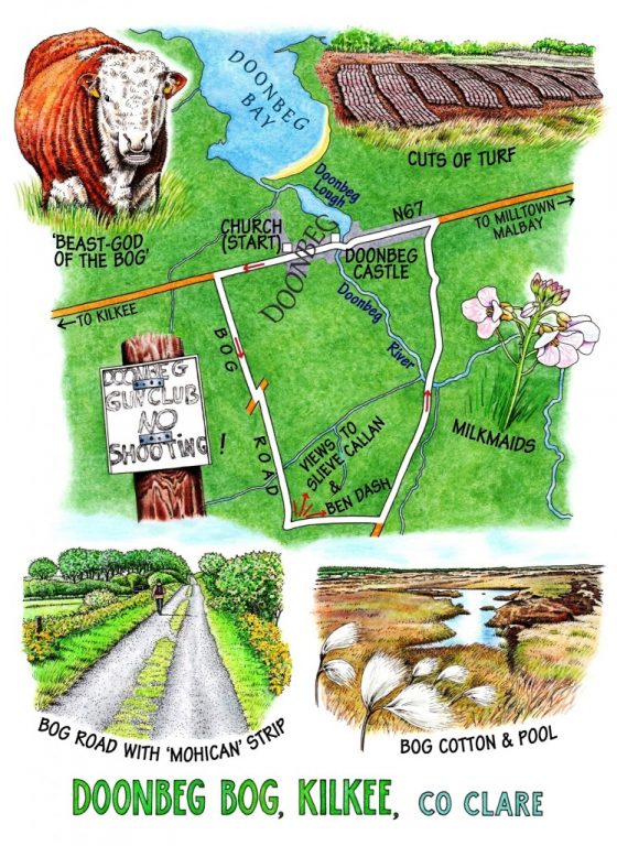
A bright windy day on the coast of south Clare, with Doonbeg in its morning slumber. The stiff sea breeze was sending the waves thumping into the cliffs just beyond the headland, and here in the village it fluttered the football banners and brought a musical chinking from the flagpole halyards in front of Doonbeg’s big octagonal church.
The fast road from Milltown Malbay to Kilkee doesn’t make the best of starts to a walk in the countryside. But that was behind us soon enough, and we were striding out along one of those country roads so typical of these flat Clare coastal hinterlands – dead straight, possessed of a central grass strip like an unrolling Mohican, and raised as a causeway above the surrounding bogland. The fields of dark peaty soil lay tufted with sedge clumps and stands of green rushes that glinted as they seethed in the strong wind. Low ridges held the farmsteads – an ancient Dutch barn orange with rust, a house with cream-painted walls and grey slate roof, a tumbledown ruin alongside, and a man’s voice, hoarse and tremendous, shouting above the foghorn mooing of cattle in the farmyard. This is proper farming country, where every driver lifts a forefinger off the steering wheel to acknowledge you along the road.
A fine brown bull stood among his harem, a copper ring through his pink nose, staring stolidly as he watched us go by. He stared through a screen of young willow leaves like some bogland beast-god, powerful and impassive. In the opposite field a young grey colt grazed among its rushes, its mane ruffled by the wind into a stiff backward crest like an ancient Celtic warrior.
A notice nailed to a telephone pole gave us a grin: ‘Doonbeg Gun Club – No Shooting’. A candidate for the most oxymoronic announcement of all time. The tarmac lane gave way to a bog road, rutted, puddled and rough, drawing an undulating line to the horizon where seven wind turbines whirled their arms above a dark conifer forest like drowning giants. There was enough wind today to light up a small city, big blustering gusts pushing in from the north, with spits of rain in their coat tails that fell on other walkers elsewhere in these flatlands. The bog road wheeled round eastwards, and the indented hummocks of Ben Dash and Slievecallan stood ahead, looming like mini-mountains in this low-lying landscape.
The bog flowers were not fully out and engaged with the weather at this early season of the year, but there were tall delicate heads of milkmaids in milky pink and blue, and dancing heads of wind-blown bog cotton around the bog pools whose surface changed colour, steel grey to jay’s-wing blue, from one step to the next.
Now the track ran through an area of harvested bog. Machines had laid neat cuts of turf along the roadside, seven precisely measured strips per cut. Beyond were dark conical mounds of hand-cut turfs drying in the wind. ‘There’s someone out there, look,’ said sharp-eyed Jane, and we stood to watch a tiny shape on the skyline bending and straightening over a turf spade, the component figure in a timeless scene of labour in the bog.
Another bull was watching us, a thickset Hereford with a curly face, knee-deep in mud. Very slowly and ruminatively he chewed, side to side, with weighty deliberation. ‘Shall I flatten that electric fence and gate, and them with it? Ah, yerra, can’t be arsed,’ and he blinked his little pink eyes and put his great head down to tear another mouthful.
The bog road met another and swung north for Doonbeg through golden gorse and red-brown myrtle, on across the clear brown Doonbeg River. A planning notice beside the track quivered in the wind. ‘Clare Coastal Wind Power Ltd… 45 turbines… 126 metres high … plus infrastructure … in the townlands of Carrowmore South, Einagh, Moanmore North, Doonbeg, Mountrivers, Sragh and Drumellihy.’ If you love plain, unaltered, subtly beautiful, dream-provoking bogland, reader – get down to Doonbeg as quick as you can, that’s all I have to say.
WAY TO GO
MAP: OS of Ireland 1:50,000 Discovery Sheet 57 or 63; downloadable map/instructions at discoverireland.ie/walking.
TRAVEL: Doonbeg is on N67 between Kilkee and Milltown Malbay. Park at church.
WALK DIRECTIONS: From church walk west (Kilkee direction) along N67 for 750 m. Left (green arrow/GA) down minor road. Dogleg over next road (GA) and on along bog road. In 1 km (⅔ mile) it bends left and continues to T-junction. Left (GA) to N67; left into Doonbeg.
LENGTH: 5 miles/8 km – allow 2 hours
GRADE: Easy
CONDITIONS: Flat bog roads; short stretch of N67
DON’T MISS:
• Views east to Ben Dash and Slievecallan
• Turf cutting activities, ancient and modern
• Wonderful colours of the iridescent bog pools and the bog flowers.
REFRESHMENTS: Plenty of choice in Doonbeg – Morrissey’s, Comerford’s and Madigan’s pubs, Tubridy’s bar/restaurant/café, and Sparrow Jack’s café.
PICNIC SPOT: Out at the turn of the bog road
ACCOMMODATION: Stella Maris Hotel, Kilkee (065-905-6455, stellamarishotel.com; €80 dble B&B, 2 nights) – long-established family hotel on the seafront.
WALKING in IRELAND: Walking tour operators, local walks including Discover Ireland’s National Loop Walks, walking festivals throughout Ireland: www.discoverireland.ie/walking and www.coillte.ie
This walk was based on: http://www.discoverireland.ie/Activities-Adventure/doonbeg-loop/80885
BOOK: Christopher’s book Walking in Ireland (Ebury Press) contains 50 of his favourite Irish Independent walks.
INFORMATION: Ennis Tourist Office: 065-682-8366; discoverireland.ie/Places-To-Go/Clare
csomerville@independent.ie
First published in FIT magazine section of the Irish Independent