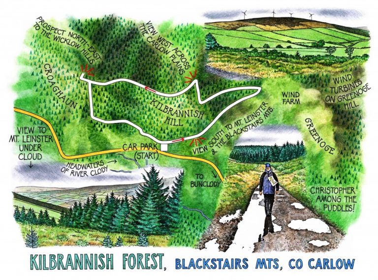
Irish Independent – WALK OF THE WEEK – Christopher Somerville
4 June 2011
98. Kilbrannish Forest, Blackstairs Mountains, Co. Carlow

Well, you can’t win ‘em all. Sooner or later the weather monster is going to pull your name out of the old sou’wester, and today it was our turn. It spat, it seethed, it poured and it pelted. Up in the northern Blackstairs it was hard to see which was Carlow and which was Wexford. The mountain had pulled the blankets over their heads and turned their backs on us. A thin cold wind stirred the cloud, but not enough to shift it from the tops. Everything in Kilbrannish Forest ran and trickled and gurgled. Each spruce needle carried its own inverted world suspended in a trembling globe of rainwater. It was absolutely not the day to go out for a walk.
You know how you can suddenly see the funny side of adverse circumstances? It was like that with Jane and me. We sat sulkily in the car, steaming up the windows and glancing at each other, till all at once we both burst out laughing. Out of the fug, into the raingear and away up the forest track. That’ll show the swine.
Looking south for the familiar broad face of Mount Leinster, we saw only a cap of leaden cloud tugged tightly down to meet the patchwork collar of rain-greened fields. Judging by the small patches of lighter hue that were inching across the land, the sun would make its way through eventually. But not yet awhile. Up went our collars, down ducked our heads, and we crunched and splashed up the gravel forest road and into the last good burst of the afternoon’s rain.
From somewhere up ahead floated a soft but insistent thump and swish, a mechanical undertone to the natural sounds of wind, rain and dripping trees. The loom of Greenoge Hill became less indistinct as the breeze thinned out the water vapour in the air, and there they were – four wind turbines whirling their arms at the nape of the hill like a band of skeletal giants out of a forgotten myth, semaphoring some hugely important but indecipherable message to the little hurrying ants that were Jane and me. The hollow masts magnified the boom and bump of the revolving blades – Whoosh-kalump! Whoosh-kalump! What must it be like to live with that, night and day?
‘Hello, lads, off for a walk?’ enquired a man entangled with a fat old golden retriever and a spruce boxer bouncing on springs. ‘Well done! Good luck, now!’ The retriever shook a shower of icy rain needles over us, the boxer nosed my hand with his punched-in snout, and they raced off through the puddles.
Kilbrannish stands high in a wind gap of the River Clody, open to all weathers. A row of upended trees lay along the trackside, their root pads exposed as big discs of dark earth and white quartz pebbles with rootlet tendrils dangling in the air – legacy of one of last winter’s storm winds that had swept in from the south-east, bowling over every tree that had not got a proper grip of the ground. The high rainfall on these exposed hillsides has given rise to ground cover that’s lush and dense – beautiful star mosses, bilberry bushes, moor grass, heather, sedge clumps, all growing in saturated profusion in the treacly black turf.
Near the crest of Kilbrannish the trees fell away and big views began to open west over the long plains of Carlow. A little further and we were gazing north from the crown of Croaghaun Hill across quilted farmlands to the high, remote and milky outlines of the south Wicklow Hills, a dreamy promise for some sunny day. Maybe it was that prospect, but as we descended the forest road towards the car the wind brushed the last of the rain up in its skirts and swept it on inland to annoy Kilkenny walkers. We were left to walk on down towards the smoking cloud-battlefield of invisible Mount Leinster, with a far view eastward to a rainy east coast soon to be bathed in evening sun.
WAY TO GO
MAP: OS of Ireland 1:50,000 Discovery 68; downloadable map/instructions (highly recommended) at www.discoverireland.ie/walking.
GPS: satmap.com
TRAVEL: Leaving Bunclody on N80 Carlow road, turn left opposite Wexford Farmers Co-op and SuperValu. Follow this mountain road for 4½ miles (7 km) to car park on right.
WALK DIRECTIONS: Walk up the ramp; right at top; follow purple arrows (PAs) up track for ½ mile (1.4 km). Opposite wind turbines, left (PA) and follow forest road. In 600m, at T-junction, right (PA) uphill. At hill crest, left (PA) for ½ mile (1.5 km) to top of Croaghan. Go past left turn with PA to reach viewpoint west over Carlow; return to PA and bear right along forest road. At bottom, left (PA) for 600m. At crossroads at foot of slope, right and follow road to car park.
LENGTH: 3½ miles/5.5 km: allow 1½ hours
GRADE: Easy
CONDITIONS: Forest tracks
DON’T MISS … !
• views south to Mt Leinster and the Blackstairs
• views west over Carlow plains
• views north-east to Wicklow Hills
REFRESHMENTS: Picnic
ACCOMMODATION: Moss Cottage, Bunclody, Co Wexford (053-937-7828; www.mosscottageireland.com) – beautifully kept house and garden.
WALKING in IRELAND: Walking tour operators, local walks including Discover Ireland’s National Loop Walks, walking festivals throughout Ireland: www.discoverireland.ie/walking.
BOOK: Christopher’s book Walking in Ireland (Ebury Press) contains 50 of his favourite Irish Independent walks.
INFORMATION:
Tourist Office: Tullow Street, Carlow (059-91-31554; www.carlowtourism.com)
csomerville@independent.ie