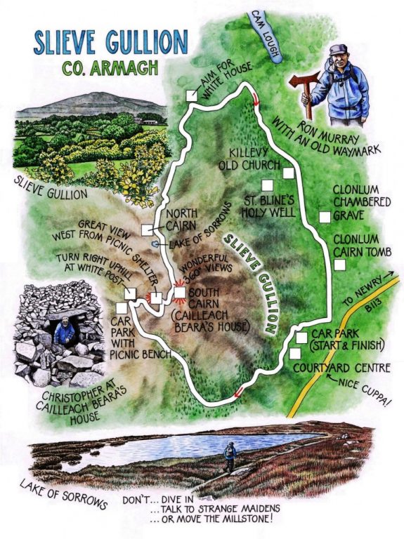
 ‘Ever smelt pine needles properly?’ enquired Ron Murray, reaching out to pluck a spiny sprig as we strolled the Forest Drive along the southern flank of Slieve Gullion. ‘Crush ‘em like this between your finger and thumb.’ I suited action to words, and sniffed deeply. A spicy blast of orange as pungent as a marmalade factory. Now why had I never noticed that before?
Until recently Ron served as officer for the Ring of Gullion Area of Outstanding Natural Beauty. When you’re out and about with someone so observant and experienced, all five senses get a re-bore. Birds, rocks, landforms, farming practices, local history, ancient monuments – all came alive for me during this walk over the big dark hump of Slieve Gullion, centrepiece of a remarkable volcanic landscape set in the green farmlands of South Armagh. Surprisingly few people – walkers or others – venture into the countryside south-west of Newry to climb the mountain and savour for themselves one of the most spectacular high-level views in Ireland.
Rowan and silver birch were coming into leaf all along the sides of Slieve Gullion. We left the trees and turned aside to climb, short and sharp, to the southern peak of the mountain. Smoking rainstorms whirled djinn-like across the lower lands as we pulled to a halt by the stony cairn and turned for a proper appreciation of the whole grand panorama.
If you can see one mile, you can see well over a hundred from the summit of Slieve Gullion. In the east Carlingford Lough, running north-east to Slieve Donard and the hummocky backbone of the Mountains of Mourne. Northwards, the tumbled hills of Antrim, with the block-head of Slemish some 50 miles off. North-west the billowy heave and roll of the Sperrins, a gleam of Lough Neagh at their feet. South-west the green-and-brown mat of Monaghan and Cavan, unrolling into the Midland plain. And down in the south, diminutive, unmistakable and as pale as tin cut-outs, the hills of Wicklow more than sixty miles away.
Until I was surfeited with this gigantic panorama, the Ring of Gullion itself had to play second fiddle. It was a series of unimaginably powerful subterranean convulsions some 60 million years ago which caused the ancient and original Slieve Gullion volcano to collapse into the great chamber that lay beneath it, sending a ripple of molten rock outwards like a stone thrown in a pond. The circular ridge solidified, then weathered over ages into the guardian hills of the Ring, a ten-mile-wide circle of craggy mini-mountains encircling Slieve Gullion like courtiers round a king.
I turned away from the breathtaking prospect at last, to find Ron beckoning like a Beatrix Potter dormouse from a little low doorway of stone set deep into the side of the cairn. On hands and knees I followed him inside, to find a chamber walled with stones neatly shaped and fitted. A neolithic passage grave under a Bronze Age cairn, say the archaeologists. Not at all, retort the romantics. Here is the house of the Cailleach Beara, the unspeakably wicked witch who turned mighty Fionn MacCumhaill into the feeblest of old men in the time it took him to dive into the Lake of Sorrows to retrieve her golden ring. Of course, the fact she’d disguised herself as a beautiful, shapely young maiden in distress had nothing to do with Fionn’s recklessness.
Ron and I strode the windy summit ridge past the Lake of Sorrows. What on earth was a millstone doing up here, half in and half out of the water? ‘Oh, a miller pinched it from the Cailleach Beara’s house,’ said Ron, ‘but it brought him such bad luck that he decided to put it back. When his donkey had got it this far, the poor thing fell down dead. So that’s where it stayed from then on. No-one quite fancies moving it …’
WAY TO GO
MAP: OS of Northern Ireland 1:50,000 Discoverer Series Sheet 29.
TRAVEL:
Bus: Service 43 (Newry-Forkhill) to Forest Park entrance
Road: N1/A1 Dublin-Newry; B113 (‘Forkhill’); in 3½ miles, right (‘Slieve Gullion Forest Park’) to car park.
WALK DIRECTIONS (Ring of Gullion Way/RGW blue arrows): From top left corner of car park (OS ref J 040196), left up path through trees. In ¼ mile join Forest Drive (038191), up slope, then level, for ¼ mile to RGW post on left (035190). Right up drive, past metal barrier; left uphill for 1½ miles to car park (018200). Beyond picnic table, right at white post, steeply uphill to South Cairn on Slieve Gullion summit (025203).
Walk past Lake of Sorrows to North Cairn (021211); then aim north for Sturgan Mountain (left of Cam Lough), then white house between you and lake. Path divides by grassy ‘lawn’ with boulder beyond; right here, aiming for house. Through gate, down to road (025230). Right along road for 3 miles, passing Killevy Old Church (040221) and Clonlum Cairn (047206), to northern entrance to Slieve Gullion Forest Park (046199). Right to car park.
LENGTH: 8 miles
GRADE: Moderate
CONDITIONS: Can be muddy
DON’T MISS … !
• Cailleach Beara’s house
• Lake of Sorrows and enchanted millstone
• sensational views from Slieve Gullion
REFRESHMENTS: Slieve Gullion Courtyard Centre café/restaurant
ACCOMMODATION: Murtagh’s Guest House, 13-15 North Street, Crossmaglen (00-44-2830-861378; aidanmurtagh@hotmail.com) – comfortable, friendly place. €28 pp B&B.
INFORMATION: www.walkni.com (Walk Northern Ireland’s ‘Quality Walks’); www.discoverireland.ie/walking (Discover Ireland’s ‘Loop Walks’)
Slieve Gullion Courtyard Centre: 00-44-2830-849220; www.clanryegroup.com
Tourist Office: Newry Town Hall (00-44-2830-268877)
csomerville@independent.ie